 |
| One satellite of a possible constellation. Photo c/o CSA. |
by Brian Orlotti
On Nov 1st, the Canadian government released a Request for Information (RFI) for the Polar Communications and Weather (PCW) project, the polar-orbiting communications and weather satellite system considered crucial to maintaining Canada's arctic sovereignty in the coming decades.
The decision is a follow-on to the February 2013 Canadian Space Agency (CSA) announcement that it was seeking partners (including other Canadian government agencies as well as international partners) to help finance the system, expected to cost roughly $600Mln CDN.
But although the RFI is generally perceived of as moving PCW a step forward, there are many hurdles still to be overcome. As outlined in the June 25th, 2013 post, "Will the Polar Communications and Weather Mission (PCW) Receive New Funding?" the current funding for the program is essentially limited to a $4.3Mln contract awarded to PCW prime contractor MacDonald Dettwiler for the preliminary phase "A" mission design in 2009 and a $5.7Mln CDN contract to ABB Canada to develop a multi-spectral imager for the PCW as part of the Space Technologies Development Program (STDP) in 2011.
Curiously enough, the ABB contract was awarded just after an October, 2011 incident in which a bad software update on Telesat’s Anik F2 satellite caused a 16-hour outage across 56 northern communities. During the outage, hundreds of people lost internet and long-distance phone service, 1000 First Air passengers were stranded over the Thanksgiving long weekend by delayed or cancelled flights, and the RCMP lost field radio communications. Although Telesat quickly notified its customers and eventually restored service, the incident was a potent reminder of how critical satellite communications are to northern Canadians.
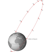
PCW is envisioned as a constellation of at least two (and perhaps more) satellites in molniya orbits, a type of highly elliptical orbit named after the Soviet/Russian Molniya (Russian for "Lightning") communications satellites which have used it since the mid-1960s.
Satellites in a molinya orbit, due to their high altitude at apogee (the point at which they are closest to Earth) can cover parts of northern Canadian territory inaccessible to geostationary satellites. A northern ground station will link the PCW constellation to communications satellites in geostationary orbit as well as other segments of Canada’s telecom infrastructure. The lifespan of each satellite is estimated at 15 years.
 |
| Typical molniya orbit. Graphic c/o Wikipedia. |
- Providing high data rate communications services for both military and commercial use.
- Providing advanced weather monitoring capability to support global weather and sea ice forecasting.
- Providing space weather monitoring capability (i.e. tracking of space debris and solar storms) The RFI has been taken as a sign of the Canadian government’s willingness to proceed with the project which, though first announced in 2009, has languished for years under a fog of political and fiscal uncertainty.
The complete RFI with requirements and initial system details is available for download at the Public Works Canada website.
In the coming decades, as the Arctic ice shrinks and the northern frontier provides greater opportunities for shipping and resource extraction, issues of sovereignty will increasingly take centre stage. The Canadian government, after years of paying lip service to these issues, now appears to be moving to address them. Space will continue to be the key to Canada’s north, enabling us to understand, exploit and protect it.

No comments:
Post a Comment